

It’s a running joke that Holland is flatter than a stroopwafel, but have you ever wondered what maps of the Netherlands reveal about the landscape? 🤔
From cities more densely packed than passengers in an NS train to wide expanses of open countryside where cows go boe, there’s much to explore.
Here are some fascinating maps of the Netherlands to help you tour this gorgeous country, whether you’re a tourist, adopted Nederlander, or just a curious Dutchie!
1. The Netherlands on a map of Europe
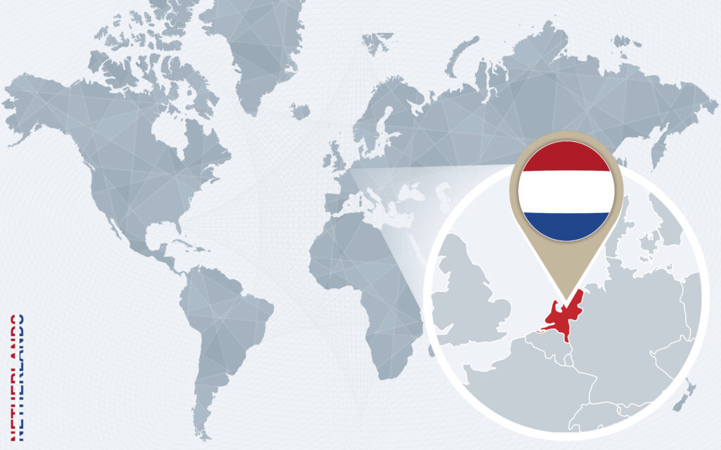
Sandwiched between Denmark in the north and Belgium in the south lies the tiny country of the Netherlands.
A haven for cheese lovers (and fans of watching people do crazy antics on bikes), this Western European country is best known for its innovative and progressive society.
2. A map of the Dutch provinces
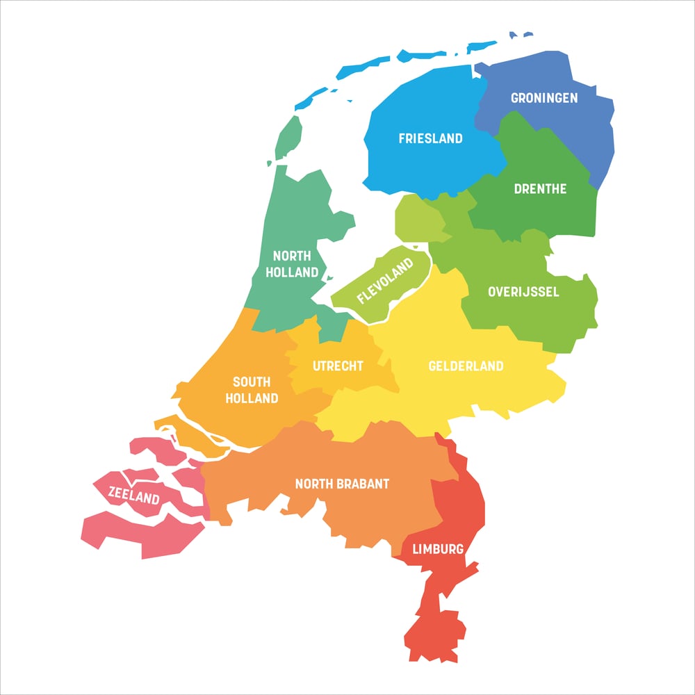
Proving that good things come in teeny-tiny packages, the European part of the Netherlands is divided into 12 provinces:
- North Holland: home to sights such as the stunning windmills of the Zaanse Schaans, the cheerful Spaarnestad of Haarlem, and Amsterdam (of course!)
- South Holland: a bustling province best known for The Hague’s International Court of Justice, the quaint university town of Leiden, and Europe’s largest seaport in Rotterdam
- Utrecht: sharing a name with its capital city, Utrecht, this province is home to dreamy historic sights like Kasteel de Haar, the largest castle in the Netherlands
- Zeeland: popularly known as New Zealand’s namesake, it also boasts one of the best storm barriers in the world, the Delta Works 🌊
- Gelderland: the Netherlands’ largest province by landmass contains sights ranging from Nijmegen, the Netherlands’ oldest city, to the unspoilt beauty of the Hoge Veluwe
- Flevoland: a marvel of Dutch engineering, the Netherlands’ youngest province was reclaimed from the sea and features former islands like the UNESCO World Heritage site Schokland
- Groningen: best known for containing the rich gas fields of the north, it is also home to the vibrant student city of Groningen (yes, the city and province share a name!)
- Drenthe: famous for its hunebedden (ancient burial mounds), this quiet province has a wealth of stunning sights, including the Dwingelderveld National Park
- Limburg: its capital, Maastricht, is a bustling student hub, but the Netherlands’ only ‘mountain’, the Vaalserberg, really puts it on the map 🗻
- Overijssel: tourists may flock to this province for Giethoorn, the Venice of the North, but the lively cities of Zwolle and Enschede also beckon for a visit
- Friesland: birthplace of the Elfstedentocht, it also boasts its own official language (Fries) and the gorgeous Wadden Islands
- North Brabant: the birthplace of Van Gogh, it’s home to places ranging from innovation hub Eindhoven to student city Tilburg
Many Dutchies tend to live in the Randstad, an area in the centre of the country that is made up of cities in the provinces of North Holland, South Holland, Flevoland, and Utrecht.
3. Is Holland crowded? A population density map of the Netherlands
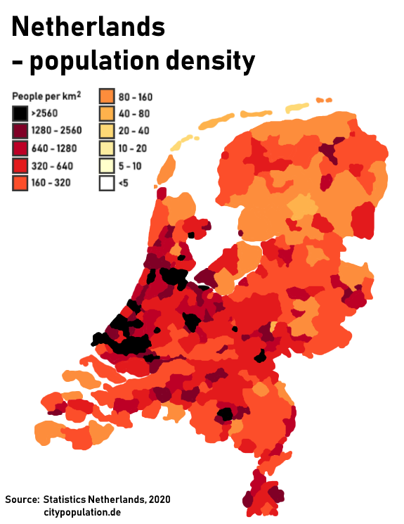
With an estimated population of over 18 million people jam-packed als haringen in een ton (like fish in a barrel) in its 41,450 square kilometres of area, we’d say that the Netherlands is quite a densely-populated country.
In fact, CBS (the Dutch Bureau of Statistics) predicted that this humble land of cheese and clogs would hit the 19 million population mark as early as 2037. That’s a lot of people in a small area!
However, the majority of the population is concentrated in the Randstad, resulting in bustling cities but a quiet countryside.
4. Map of the Netherlands below sea level
Let’s just say that there’s a reason why the Netherlands, Belgium, and Luxembourg have historically been nicknamed the ‘Low Countries.’
About 26% of the Netherlands lies below sea level, and the lowest point in the country is the Zuidplaspolder at around 6.76 metres below sea level in Nieuwerkerk aan den IJssel.

READ MORE | Dutch Quirk #124: Not care about the fact that they’re living below sea level
That means that, without the Netherlands’ extensive system of dikes and dams, if you were to stand in front of Amsterdam Central Station, the sea would be well over your head — help!
5. The Dutch mountains: a topographic map of the Netherlands
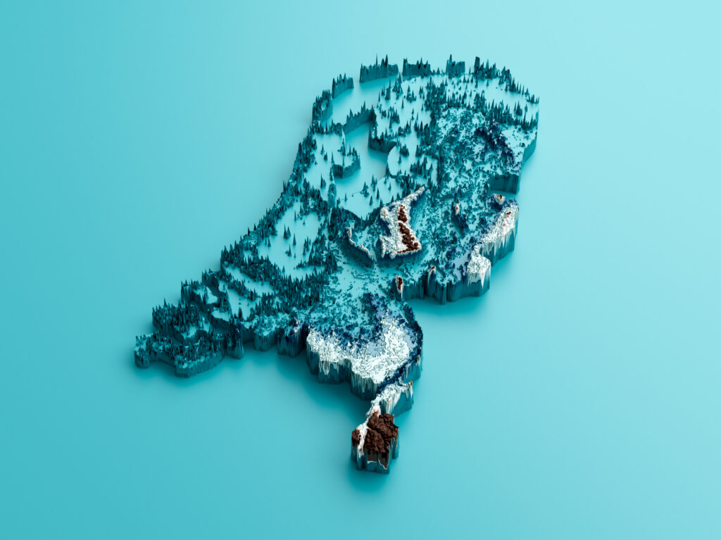
Although most of the country is as flat as a pannenkoek (pancake), the Netherlands does have one major point of elevation: the Vaalserberg.
READ MORE | Did you know there were mountains in the Netherlands?
This “Dutch mountain” is just a smidge over 322 metres tall, making it taller than three Statues of Liberty (who stands at a more modest 90 metres herself). 🗽
However, if we take the entire Kingdom of the Netherlands into the equation, the highest point is actually on the Caribbean island of Saba, where the summit of Mount Scenery, an extinct volcano, is a steep 887 metres tall.
6. Dutch land reclamation efforts: mapped
[GIF] Land Reclamation in the Netherlands 1300-2000 (Individual Images in Comments) [500×621]
byu/Theman77777 inMapPorn

Though reclaiming a whole province (hoi, Flevoland 👋) from the sea was bloody impressive, it barely scratches the surface of what makes Dutchies true masters of the elements.
The Dutch are considered masters of water management — after all, God might have created the world, but the Dutch created the Netherlands. 😉
7. Bike paths in the Netherlands
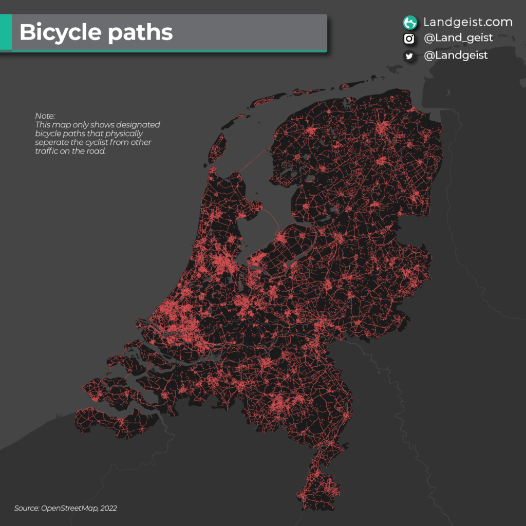
With approximately 23 million owned (and frequently stolen) bikes by 17.6 million Dutchies, we can definitely see why the Netherlands has mapped such a robust system of bike paths.
READ MORE | From omafiets, to mamafiets, and bakfiets — Dutch bikes, explained
The map of bike networks in the Netherlands shows the Dutch commitment to biking — not just from the people but also in terms of government infrastructure.
8. Mapped: the difference between Holland and the Netherlands
Despite often being used synonymously (and cheers of Hup Holland Hup whenever the country competes in a match ⚽️), Holland and the Netherlands don’t refer to the same area.
READ MORE | What’s the difference between Holland and the Netherlands?
“Holland” comprises the provinces of North and South Holland, whilst “the Netherlands” refers to the country as a whole.
9. Map of the Caribbean Netherlands and Dutch constituent countries
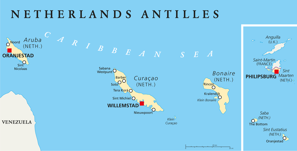
If you thought the Netherlands was just a tiny European country with weed and windmills, think again. 😉
Squinting at a world map will reveal three tiny islands in the Caribbean that also belong to the Kingdom of the Netherlands: Bonaire, Sint Eustatius, and Saba.
These are considered special municipalities of the Netherlands located overseas and can take part in Dutch and European elections.
In addition to the previous tiny islands in the Caribbean, you’ll find a further three islands on a map of the Dutch Caribbean.
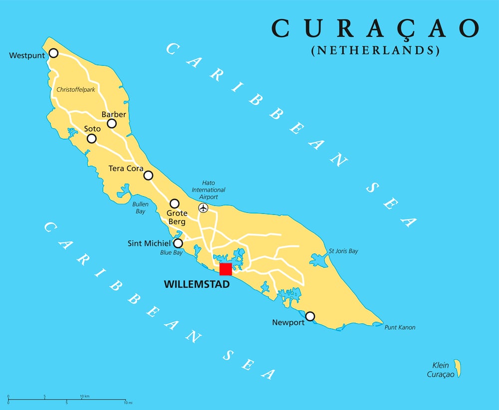
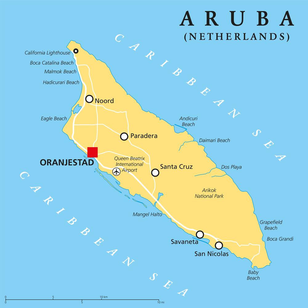
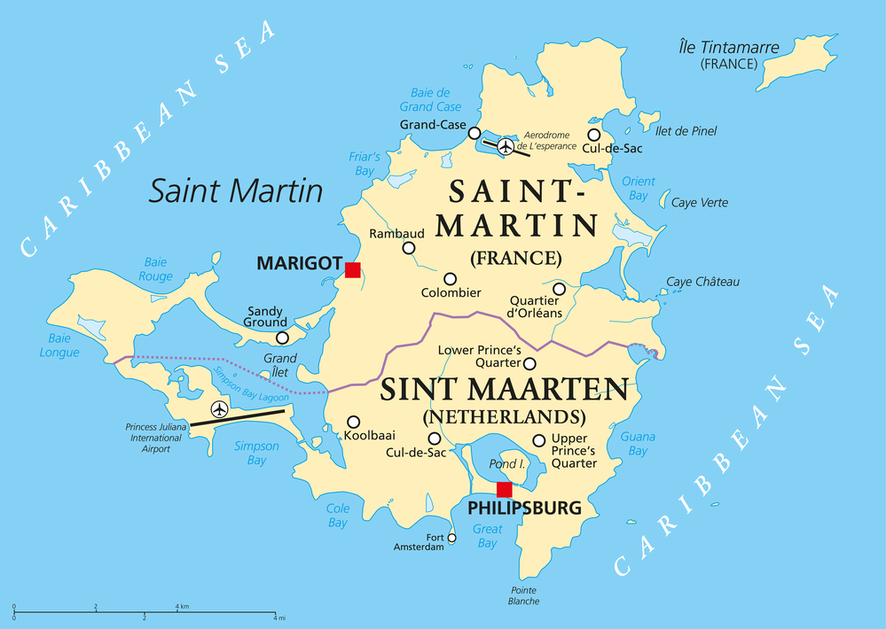
These are the Netherlands’ constituent countries: Aruba, Curaçao, and Sint Maarten.
Unlike municipalities, these countries are relatively autonomous (they even have their own parliaments), though they depend on the Netherlands for things like defence.
Well, there you have it: a fascinating exploration of the Netherlands’ landscape through a collection of maps.
Which was your favourite map of the Netherlands? Tell us all about it in the comments below!
Maps in the Netherlands: Frequently asked questions
Is the Netherlands crowded?
While the whole country of the Netherlands has only the 27th highest population density in the world, the capital city of Amsterdam houses 4,439 people per square kilometre. In comparison, Hong Kong has 6,789 people per square kilometre. Many internationals find that the Dutch cities are more crowded than what they’re used to.
Is a part of the Netherlands really below sea level?
Approximately 26% of the Netherlands lies below sea level, meaning that quite a bit of the country would be underwater if it weren’t for the Dutchies’ extensive system of dikes.
What is the lowest point in the Netherlands?
The Netherlands’ lowest point is the Zuidplaspolder near Rotterdam, which sits at over 6.76 metres below sea level.
Does the Netherlands have mountains?
Surprisingly, it does… kind of. The European part of the Netherlands is home to the Vaalserberg, which is a little over 322 metres tall.
Whilst not the most physically impressive sight on the horizon, it’s still over three times as tall as the Statue of Liberty.
Meanwhile, the Caribbean Netherlands boasts Mount Scenery — an 887-metre-tall extinct volcano.
Does the Netherlands have more bikes than people?
The Netherlands has a whopping 23 million bikes for 17.8 million people. Now that’s a lot of fietsen (bikes)! 🙌
How many provinces does the Netherlands have?
The Netherlands has a total of twelve provinces:
- Groningen, Friesland, and Drenthe in the north
- Utrecht, North and South Holland, and Flevoland in the Randstad
- Gelderland and Overijssel in the east
- Zeeland, North Brabant, and Limburg in the south
Which Dutch provinces border Germany?
All of the provinces on the eastern side of the Netherlands border Germany; these are Groningen, Drenthe, Overijssel, Gelderland, and Limburg.

Every year for Christmas, my family uses a different country for our theme. This year we are doing the Netherlands. The information you have shared is appreciated!
Very nice way of presenting these facts.